Lidar Surveys in San Antonio, TX – High-Precision Laser Mapping

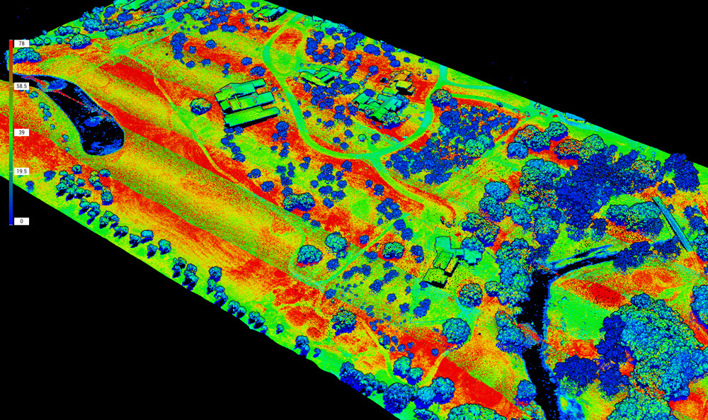
When your project demands extremely accurate elevation and surface data, Lidar surveying is the gold standard. At Survey Works, we offer professional Lidar surveys in San Antonio using industry-leading laser scanning technology. Our Lidar (Light Detection and Ranging) systems capture millions of data points per second to create high-resolution 3D maps of terrain, structures, vegetation, and built environments—with accuracy down to the centimeter.
Whether you’re designing infrastructure, mapping utilities, or managing complex development sites, our Lidar solutions provide the clarity and detail you need.
Professional Lidar Surveying Services
What Is a Lidar Survey?
Lidar surveying uses a laser scanner mounted to a drone, vehicle, or tripod to emit rapid laser pulses across a site. Each pulse reflects off surfaces and returns to the sensor, creating a dense point cloud that models surface elevations and features in 3D. Unlike photogrammetry, Lidar can penetrate through vegetation to capture bare earth topography—even in heavily wooded or obstructed areas.
Why Choose Lidar Over Traditional Surveying?
Lidar offers significant advantages for specific applications:
- Ultra-dense point cloud data for detailed surface modeling
- Penetration through vegetation and brush to reveal ground surface
- Fast coverage of large or inaccessible areas
- Improved vertical accuracy for slope analysis, grading, and drainage
- Ideal for high-resolution topographic mapping
Survey Works integrates Lidar data with conventional control points and GPS ground truthing to ensure survey-grade precision across every output.
Lidar Applications in San Antonio
We serve a wide range of industries across Central Texas that require Lidar data for planning, design, and execution. Common use cases include:
- Transportation projects – roadway design, slope modeling, right-of-way mapping
- Utility corridors – pipeline routing, overhead line clearance, as-built documentation
- Land development – detailed site grading, drainage mapping, and elevation modeling
- Environmental and floodplain analysis – wetland delineation, watershed mapping, flood risk mitigation
- Urban modeling – 3D city mapping, architectural restoration, volumetric analysis
Aerial and Terrestrial Lidar Options
Depending on your site conditions and project goals, we offer both aerial Lidar surveys (drone or aircraft-mounted) and terrestrial Lidar surveys (tripod or vehicle-mounted scanners). Our team will help you determine the best approach based on coverage area, vegetation, accessibility, and resolution requirements.
Accurate. Scalable. Actionable.
At Survey Works, we don’t just deliver Lidar point clouds—we deliver actionable datasets that integrate directly with your engineering, CAD, or GIS workflows. We process raw Lidar data into:
- Contour maps
- Digital Elevation Models (DEMs)
- Cross-sections and profiles
- Volume calculations
- Topographic surfaces
We can also overlay Lidar data with orthophotos, site plans, and utility layers for full situational awareness.
Lidar Surveys Across Greater San Antonio
Our Lidar survey teams are available throughout San Antonio and nearby areas, including:
- Boerne
- Alamo Ranch
- Live Oak
- Castle Hills
- New Braunfels
- Schertz
- Selma
- Universal City
We mobilize quickly and can provide fast turnaround on urgent projects.
Request a Lidar Survey in San Antonio
Need precision-grade topographic or surface data? Contact Survey Works today for a professional Lidar survey in San Antonio. Call (210) 955-9838, email info@surveyworks.com, or fill out our online request form to receive a detailed proposal. We’ll recommend the right survey method and provide transparent pricing—backed by licensed expertise and local experience.
