The process of purchasing new land, making improvements to existing property, or simply implementing or renewing insurance often requires reference to an elevation certificate. For current or prospective property owners, the process for obtaining these certificates may be unfamiliar, and the FEMA requirements could seem a bit intimidating. Fortunately, the steps you'll need to take can be navigated with the assistance of a land surveyor.
Since 2015, Survey Works has provided the Austin area with a range of surveyor services, including all stages of telecom surveys as well as surveys for property owners encountering the flood insurance industry. We are dedicated to ensuring all elevation certificates provide the precise, accurate information necessary to balance potential insurance premium savings with the knowledge that ensures all structures are safe.
What Is an Elevation Certificate?
An elevation certificate, also referred to as a flood elevation certificate, is a document provided by the Federal Emergency Management Agency (FEMA) for use by the National Flood Insurance Program (NFIP). To complete the certificate, a land surveyor will research the current FEMA data to determine its base flood elevation (BFE). This BFE estimates the maximum level of flooding that may be produced on the property by a 100-year storm, the strongest flood-producing storm likely in any given 100 year period.
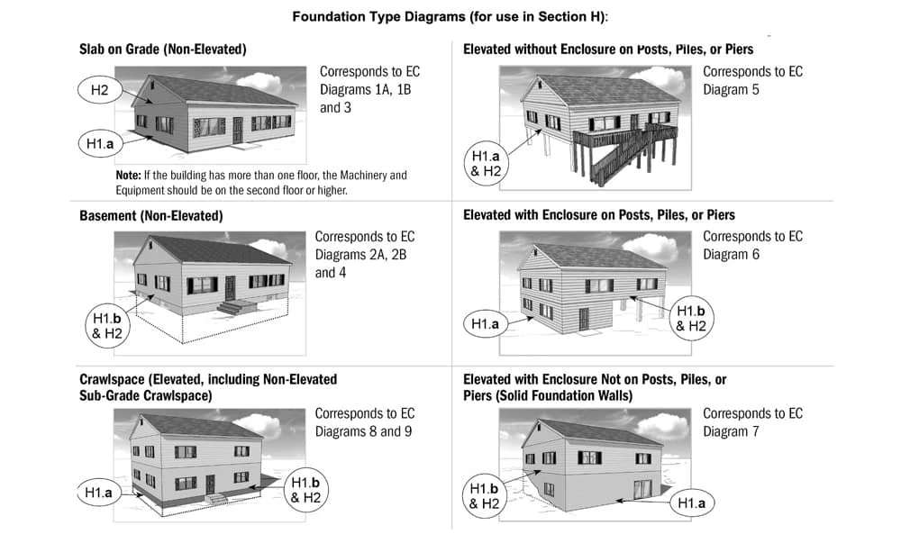
The surveyor will then take various measurements regarding one specified structure on the property. Aside from land elevation, other information necessary includes:
- The type of structure on the property
- Finished floor elevations
- Square footage of basement and/or crawl spaces
- Elevations of any machinery servicing the building, including elevators, air conditioners, and furnaces
After all the necessary measurements and data have been collected and analyzed, the elevation certificate is completed and sealed, ready for submission to the necessary parties.
Why Do You Need an Elevation Certificate?
If you own property or are about to purchase or improve a property, particularly those in areas that have flooded previously or in areas near water, you may need to acquire flood insurance to protect your investment. Mortgage lenders, home equity lenders, insurance estimators, and public officials may require you to purchase flood insurance as part of the sale or purchase of a home or commercial building, or prior to its improvement. An elevation certificate is essential to determine your property's location as compared to the base flood elevation.
The FEMA elevation certificate records this information and registers compliance with NFIP regulations. Then, your insurance estimator or the requesting public officials can utilize the data at hand and compare it with current FEMA data to determine your property's flood risk. Once those conclusions are made, the certificate will justify the necessary insurance premiums to accurately reflect your flood risk.
In a few cases, despite inclusion in a flood hazard zone, your property may be at a high enough elevation to exclude it from flood risk. In these circumstances, an elevation certificate can justify changes to the flood risk map and ultimately the risk designators to your property. Either a letter of map amendment (LOMA) or letter of map revision (LOMR) could reduce your flood insurance requirements.
Who Can Prepare an Elevation Certificate?
Elevation certificates may only be prepared by a licensed and certified land surveyor, properly registered engineer, or an authorized architect. This professional must accurately gather and record data, as this data remains present on property records as well as insurance premium determinations.
Contact Survey Works Today
If you require an elevation certificate, our team can help you navigate the process; simply call 512-599-8067 or contact us online to get started.