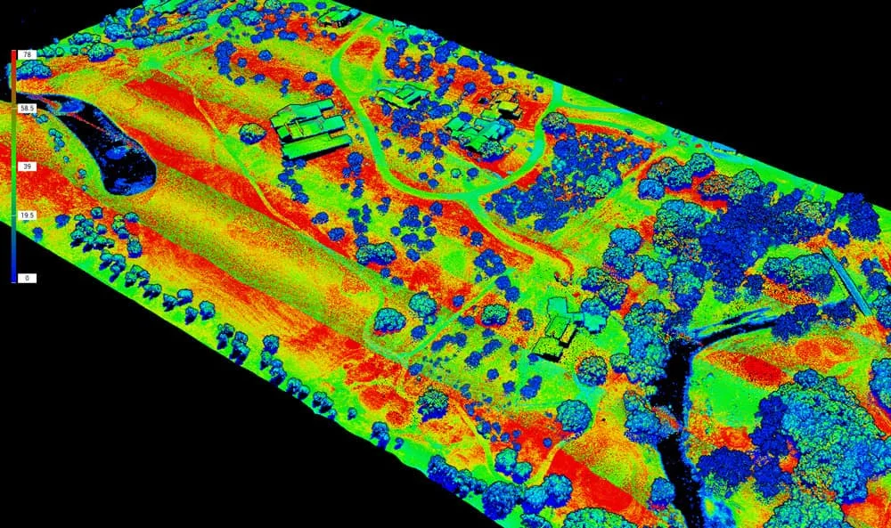
Survey Works provides LiDAR surveys and LiDAR mapping for civil engineers, infrastructure teams, land developers, environmental consultants, and utility planners working across Texas. LiDAR (Light Detection and Ranging) uses a laser scanner, mounted on a drone, aircraft, vehicle, or tripod, to emit millions of laser pulses per second across a site. Each pulse reflects off surfaces and returns to the sensor, building a dense three-dimensional point cloud of the terrain and features on it. For projects that need highly accurate surface data, dense contours, or ground models through heavy vegetation, LiDAR delivers data that conventional survey methods cannot match.
LiDAR work is also referred to as LiDAR mapping, LiDAR scanning, or laser scanning depending on the industry and the deliverable. The sealed product Survey Works delivers is prepared by a licensed land surveyor, with survey-grade control points tying the point cloud to a defensible coordinate system so the output integrates cleanly with CAD, civil engineering, and GIS workflows.
How LiDAR captures a site
A LiDAR system combines a laser scanner, a precise positioning system, and an inertial measurement unit to record the location of each laser return. From a drone at altitude, a single flight can collect millions of points across a large site in a fraction of the time a ground crew would need to cover the same area with a rod and GPS. From a tripod, the same technology captures a dense scan of a specific structure or feature at millimeter-level detail. The raw point cloud is then processed into the deliverables the design team actually works in.
Typical LiDAR outputs include bare-earth topography, dense contour maps, Digital Elevation Models (DEMs) and Digital Terrain Models (DTMs), cross-sections and profiles along designed routes, volumetric calculations for stockpiles or earthwork, and integrated deliverables that overlay the LiDAR data with orthophotos, site plans, or existing utility layers.
When LiDAR beats a conventional survey
LiDAR is not the right tool for every project. On small open sites with clear boundaries, a traditional field crew produces a cleaner result faster. LiDAR's advantage shows up on specific conditions where the density, speed, or vegetation-penetration of the technology changes the economics of the job.
"We recommend LiDAR over traditional survey methods when there is heavy tree or brush coverage, extreme elevation changes in the lay of the land, or if a property is multiple acres. A large plot of land containing vegetation could take a crew using conventional survey methods weeks to complete. A drone equipped with LiDAR could complete the same survey in days instead of weeks."
— Byron Bragg, SIT, UAS Pilot
The weeks-to-days framing drives most LiDAR engagements. On a wooded multi-acre site, a conventional ground crew has to hike every line, set every point, and manually clear sightlines to get a usable topographic surface. A LiDAR drone flies above the canopy, captures the ground surface through the gaps, and produces a point cloud that reveals the bare earth underneath. The schedule compression is real, and on large or inaccessible parcels it often becomes the only practical way to deliver the data the design team needs.
Aerial and terrestrial LiDAR
Survey Works runs both aerial LiDAR (drone-mounted) and terrestrial LiDAR (tripod-mounted) depending on the project. Aerial LiDAR is the right choice for large-area topography, linear infrastructure corridors, and sites where ground access is limited or unsafe. Terrestrial LiDAR is the right choice for dense capture of specific structures, facades, narrow utility corridors, and interior spaces where a drone cannot fly. The method call happens during the initial scope conversation, based on the coverage area, accuracy requirements, vegetation density, and accessibility of the site.
LiDAR applications we handle
LiDAR mapping feeds a wide range of engineering and planning deliverables. Applications we routinely run LiDAR for include:
- Transportation projects: roadway design, slope modeling, right-of-way mapping
- Utility corridors: pipeline routing, overhead line clearance, as-built documentation
- Land development: detailed site grading, drainage planning, and elevation modeling
- Environmental and floodplain analysis: watershed mapping, flood risk studies
- Construction and as-built documentation on projects where traditional methods would be too slow or access-limited
- Volumetric analysis on stockpiles, quarries, and active earthwork sites
Each LiDAR capture is tied to survey-grade ground control, so the point cloud aligns with the boundary, any existing site design, and the civil engineer's coordinate system.
From point cloud to CAD-ready deliverable
LiDAR data is only useful once the point cloud is processed into the formats the design team works in. Survey Works processes raw LiDAR into contour maps, DEMs, cross-sections, volume calculations, topographic surfaces, and combined deliverables that overlay LiDAR with orthophotos, utility layers, or site plans. For projects that also need aerial imagery, LiDAR captures often pair with a drone survey flight to deliver both the point cloud and high-resolution orthorectified imagery on the same mobilization.